
- Home
- Companies
- AIRPHOTON / GRASP Earth.
- Articles
- 3 Dreams Project - Case Study
3 Dreams Project - Case Study
The 3DREAMS project presents the concept of a 3D radiative Digital Twin Earth (DTE) and how it can be used to understand the effects of surface heterogeneities on aerosol retrieval from multi-angular observations. A series of realistic scenes will be generated and used by the Eradiate radiative transfer (RT) model for the simulation of satellite observations. The impact of various types of surface heterogeneities on aerosol retrieval will be based on the Generalized Retrieval of Atmosphere and Surface Properties (GRASP) algorithm which relies on the inversion of a 1D RT model.
The objective of this study is to characterise and quantify the uncertainties of aerosol and surface property retrieval from the processing of multi-angular observations (e.g., SLSTR, 3MI). It will begin with simple cases of surface heterogeneity, then progress to more complex 3D scenes generated after key AERONET stations located over heterogeneous surfaces.
This research project will contribute to ESA initiatives, such as Science Hub, by providing practical examples of synergistic usage of open-source software like GRASP and Eradiate with data to support their usage throughout three main results:
- The quantification of the impact of 3D surface heterogeneity on satellite observations through the simulation of scenarios featuring various combinations of atmospheric and heterogeneous surface conditions;
- The quantification of the impact of 3D surface heterogeneity on Essential Climate Variables (ECV) retrieval through remote sensing data inversion;
- Recommendations to alleviate or account for these effects on the basis of the simulation/inversion studies performed in the project.
It will also illustrate the benefit of a component like a 3D radiative DTE to benchmark existing retrieval algorithms or for the preparation of new satellite missions. In this context, it can serve as an example for future Atmospheric Correction Inter-comparison eXercise (ACIX) phases (Doxani et al., 2023). The 3DREAMS project will contribute to the Rayference and GRASP SMEs’ joint effort to:
- Promote the development of state-of-the-art open-source scientific software to the benefit of the Earth Observation scientific community;
- Benefit from their complementary scientific expertise in RT and satellite data processing;
- Initiate the development of a 3D radiative DTE component.
It is expected that this first project dedicated to study the effects of surface heterogeneities on retrieval processes based on 1D inversion will be followed by a similar approach to study the effects of atmospheric inhomogeneity such as fire plumes and broken cloud fields.
Overall, the outcomes of this project contribute to a deeper understanding and reduction of the existing uncertainties in aerosol and surface characterisation from multi-angular remote sensing measurements which are a crucial part of global climate studies.
This project has been funded by the ESA open call for proposals for EO innovation.
A rigorous experimental plan will be used to address the proposed topic. All studies in this project will be based on controlled synthetic experiments starting from ideal homogeneous atmosphere/surface conditions and ending up with realistic heterogenous cases. The implementation aspects of the study consists of several steps described below.
Step 1. Harmonisation of (i) the Eradiate forward model used for synthetic data generation and (ii) the GRASP forward model used in the retrieval. The study here will be based on the simulation of uniform surface cases (reference cases). For these reference cases the radiative transfer calculations from GRASP and Eradiate will be run and compared with each other to ensure full consistency of aerosol and surface models.
Step 2. Study of accuracy and uncertainties of the aerosol and surface retrieval on the reference homogeneous simulation cases. In this step, the GRASP algorithm will be used to retrieve aerosol and surface properties from reference homogeneous simulations and the performance of the GRASP retrieval will be evaluated using aforementioned requirements for aerosol and surface characterisation.
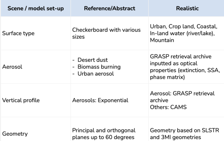
Step 3. Retrieval of aerosol and surface properties for heterogeneous “abstract” and “realistic” cases. Here, the GRASP algorithm will be tested on heterogeneous simulated scenarios and the performance of GRASP retrieval will be evaluated using the aforementioned requirements for aerosol and surface characterisation.
Step 4. Investigation of 3D effect for aerosol and surface retrieval. The retrieval results from previous steps will be investigated in detail. Analysing and comparing aerosol and surface properties retrieved from homogeneous and heterogeneous scenarios the 3D effect will be quantified and the condition of their manifestation will be studied.
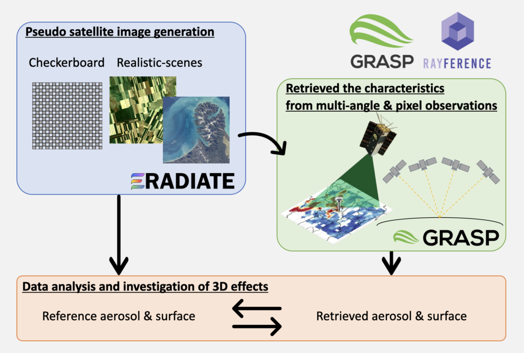
Figure 1: Illustration of the proposed approach
GRASP SAS shorten from ‘Generalized Retrieval of Atmosphere and Surface Properties” is a company that was founded in February 2015 with the main goal of developing remote sensing algorithms and scientific methods for environment studies of the atmosphere and surface of the Earth.
GRASP SAS developed a code “GRASP” for advanced aerosol and surface retrieval from remote sensing measurements. GRASP SAS comprises a unique team with the full understanding of all aspects of the code, including the physical and mathematical foundations, as well as software optimisation. The GRASP team has led several projects to retrieve atmosphere and surface parameters from different satellite sensors (POLDER, MERIS, AATSR, OLCI/S-3 TROPOMI/S-5p, Himawari), their synergies (MERIS+AATSR) as well as on the synergy of the ground-based and satellite (e.g., AERONET+OLCI/S-3, AERONET+TROPOMI/S-5p). as well as for passive and active observations as discussed by Lopatin et al. (2013, 2021), Dubovik et al. (2021). Therefore, the synergetic retrieval developments are natural GRASP algorithm evolution to cover combinations of different satellite measurements.
Rayference SRL is a SME founded in 2013, active in the Earth Observation field and providing expertise in 1D/3D radiative transfer modelling. Rayference’s expertise is applied in areas such as the retrieval of aerosol, cloud and surface properties from space observations, vicarious calibration, fundamental and thematic climate data record generation or sensitivity analyses for the preparation of new space missions and associated services.
Rayference SRL’s portfolio includes the open-source 3D radiative transfer model Eradiate, of which Rayference is the developer and maintainer. Eradiate is funded within the Copernicus programme through a project managed by the European Space Agency; the development team is composed of physicists and engineers producing high-quality software both in terms of science and technology. Rayference’s expertise also extends to the retrieval of Earth system components from space observations. Given its experience with both forward and inverse modelling, Rayference can provide realistic simulations of satellite acquisition, including hyperspectral sensors, using Eradiate.