

Calpuff & Calpuff View: What’s the Difference?
Lakes Software recently announced its acquisition of the CALPUFF modeling system from Exponent. Because Lakes’ CALPUFF View interface is well known throughout the modeling community, some modelers were not aware of the differences between this application and the stand-alone modeling system. This tip will explain the relationship between the modeling system and the CALPUFF View interface.
CALPUFF is an advanced non-steady-state meteorological and air quality modeling system consisting of three primary components:
- CALMET – a diagnostic three-dimensional meteorological model
- CALPUFF – an air quality dispersion model
- CALPOST – a post-processing package
In addition to these components, there are numerous processors that can be used to develop model inputs (e.g., geophysical & meteorological data pre-processing) or post-process and analyze modeling results .
The entire CALPUFF system is distributed for free, and all components / processors can be executed via the command line. Components are archived as zip files containing the executable, model code, and configuration files. Most also contain sample input files.
Use of the system applies to a wide variety of scenarios including:
- Long-range transport of pollutants (beyond 50km of source emissions)
- Near-field impacts in regions with complex dispersion situations including:
- Complex terrain
- Stagnation, inversion, recirculation, and fumigation conditions
- Overwater transport and coastal conditions
- Light or calm wind conditions
- Visibility assessments and Federal Class I area impact studies
- Secondary pollutant formation
- And more!
Visit CALPUFF.org today, the new home of the CALPUFF model!
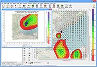
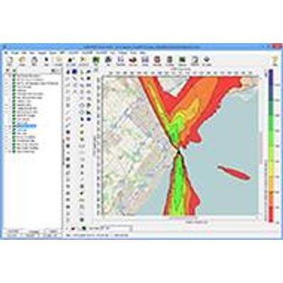
- A friendly, intuitive interface which provides graphical access to all model inputs and outputs. The display can be easily customized to suit the needs of individual modelers.
- Automatic access to high-resolution satellite and street map imagery in the main display
- Graphical tools to easily view and sort model output. Modelers can also export data into more user-friendly data formats such as CSV and XLSX.
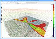
- The ability to graphically display individual puffs in the Google Earth three-dimensional GIS application.
Reach out to our Sales Team now to learn more about purchasing your copy of CALPUFF View!