

Kermap
3 software found
Kermap software
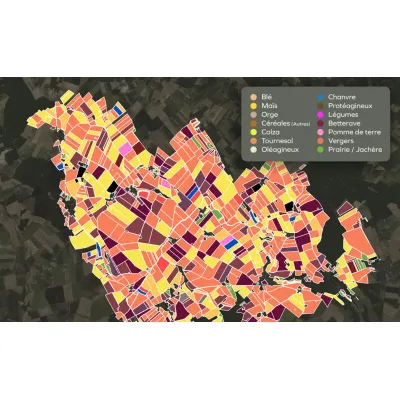
Satellite and AI for Sustainable Farming
Automatized crop monitoring, field by field, at any scale. Kermap contributes to sustainable farming initiatives by providing crop analytics through satellite analysis. We combine expertise in remote sensing and artificial intelligence to deliver quick, large-scale multi-year crop identification. Our indicators and datavisualization tools provide actionable crop monitoring to anticipate on market trends, assess logistics needs, and certify the impact of environmental incentives for players involved in the transition to sustainable agriculture.
Environment Services
KERMAP produces, analyzes and interprets Earth observation data crucial to sustainable land management. These indicators help public and private players contain land take and preserve ecological continuity, healthy forests as well as ecosystemic services identification and inventory.

Urban Planning Services
We provide diagnosis and decision support tools for sustainable cities through land-use, vegetation and climate mapping. Our cartographic products are enhanced by geospatial analysis and predictive models for urban development professionals. The rely on satellite imagery and aerial photographs, processed through expert photo-interpretation and innovative, time and cost-effective AI techniques developed in-house by Kermap.