
TK Consult AG
- Home
- Companies
- TK Consult AG
- Software
6 software found
TK Consult AG software

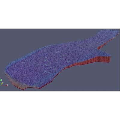
Groundwater and Contaminant and Heat Transport Software
The SPRING finite element-based software is developed by our german partner delta h. SPRING main capabilities are: 2D/3D groundwater flow; steady-state/transient, saturated and unsaturated flow regimes; density dependent heat and contaminant transport; model calibration; definition of well catchment areas.
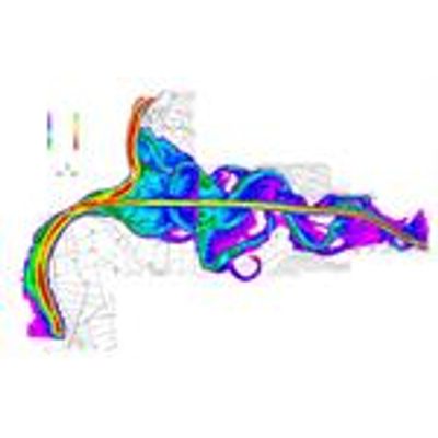
Surface Water Software
The software Floris2000 was originally developed by the Laboratory for hydraulic engineering, hydrology and Glaciology of the ETH in Zürich. The firm Scietec developed the user-friendly interface FluxDSS/Designer to facilitate the pre- and post-processing and improved some of the capabilities of the aforementioned code with regard to regulated hydraulic power plants.
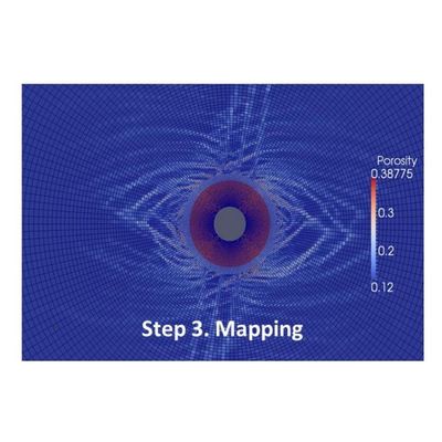
Visualization / GIS Software
Model outputs (just numbers) are often transformed according to the wish of our clients. To that end, we develop scripting tools for format-exchanging and visualization interfaces that meet the client needs.
These interfaces are often based upon GIS software packages like QGIS or 3D visualizations in Paraview or TecPlot. To that end, our programming engineers are 'multi-lingual' (Fortran, C++, C#, Perl, R, Matlab, Julia, Haskell, Java, Python, html, php, css, bootstrap, JavaScript, etc.).
Software Development
Sophisticated models demand sophisticated software packages. The quality of our work is the result of the combination of engineering skills and the mastery in using well-known and verified software packages.
Our engineers actively cooperate in the development and enrichment of the aforementioned software packages. This warrants an up-to-date and in-depth know-how of the software capabilities and therefore, this is synonym with good performance.
In addition, we develop own different software toolboxes. To that end, our programming engineers are 'multi-lingual' (Fortran, C++, C#, Perl, R, Matlab, Julia, Haskell, Java, Python, html, php, css, bootstrap, JavaScript, etc.). Model outputs (just numbers) are often transformed according to the wish of our clients. To that end, we develop scripting tools for format-exchanging and visualization interfaces that meet the client needs. These interfaces are often based upon GIS software packages like QGIS or 3D viewers like Paraview or Tecplot.
Programming languages
Sometimes specific models demand new calculation options that have to be implemented in existing packages. Or input-data needs sometimes to be reformatted; and we always make sure our workflow keeps automatically reproducible. To that end, we master different programming scientific languages like Fortran, C++, C#, etc. The use of scientific, object oriented, programming languages renders our home-made software with speed and flexibility. The main disadvantage of such languages is that they are not often user-friendly, what makes the pre and post-processing of data and outputs a difficult task.
Pre-processing of data is often carried by means of scripting languages like perl, Matlab, R, etc. Usually, the geographical data sets are linked to GIS packages like QGIS.
Another set of scripting languages, e.g., Matlab, Java, VisualBasic, etc., are used to generate Graphical User Interfaces (GUI) to facilitate the tasks of pre- and post-processing. This all-in-one tools are easy to use.

Model calibration and uncertainty
Models are, by nature, uncertain due to scarcity/lack of quality of measurements. Therefore, model parameters and model structure need to be calibrated in an automatic manner. Our engineers have developed automatic tools for model calibration based on available measurements. Such tools also allow to address the inherent uncertainty of the model.