


- Home
- Companies
- Hangzhou CHNSpec Technology
- Products
- Figspec - Model FS60 - Drone-Based ...
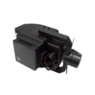
Figspec - Model FS60 -Drone-Based Microscope Hyperspectral Measurement System
- Dajiang M300RTK (Dajiang M600Pro optional) is used as the flight carrying platform;
- High SNR ultra high speed spectral scanning imaging device is used to provide highly stable spectral image acquisition;
- The self-developed image processing algorithm with high efficiency and low power consumption is adopted to greatly extend the flight time of the whole machine and reduce the system power consumption;
- Through real-time measurement of spectral image information of plants, water bodies, soil and other surface objects, application and precision agriculture, crop growth and yield assessment, forest pest monitoring and fire prevention monitoring, coastline and marine environment monitoring, lake and watershed environment monitoring and other applications;
- The system design is compact, and the spectral resolution of the imaging spectrometer host is up to 2.5 nm;
- The whole machine consists of a highly stable PTZ, a hyperspectral imager, an embedded data acquisition, processing and storage unit, a wireless image transmission system, a GPS-RTK navigation system, a ground receiving workstation, a ground control system, and a reflectance calibration board.
Flight unit parameters(M300RTK):
Size: Size (unfolded, excluding blades): 810 × six hundred and seventy × 430 mm (long × wide × High), Size (folded, including blades): 430 × four hundred and twenty × 430 mm (long × wide × High)
Symmetrical motor wheelbase: 895 mm
Weight (including lower single pan tilt support): Empty weight (excluding battery): 3.6 kg, Empty weight (including dual batteries): 6.3 kg
Maximum load of shock absorption ball of single pan tilt: 930g
Maximum takeoff weight: 9 kg
Working frequency: 2.4000-2.4835 GHz;5.725-5.850 GHz
Transmitting power(EIRP): 2.4000-2.4835 GHz:29.5 dBm(FCC);18.5dBm(CE)18.5 dBm(SRRC);18.5dBm(MIC)5.725-5.850 GHz:28.5 dBm(FCC);12.5dBm(CE)28.5 dBm(SRRC)
Hover accuracy(P-GPS): Vertical: ± 0.1 m (when visual positioning works normally) ± 0.5 m (when GPS works normally) ± 0.1 m (when RTK positioning works normally), Horizontal: ± 0.3 m (when visual positioning works normally) ± 1.5 m (when GPS works normally) ± 0.1 m (when RTK positioning works normally)
RTK Position accuracy: At RTK FIX: 1 cm+1 ppm (horizontal) 1.5 cm+1 ppm (vertical)
Maximum rotation angular velocity: Pitch axis: 300 °/s Heading axis: 100 °/s
Maximum pitch angle: 30 ° (P mode and forward vision system enabled: 25 °)
Maximum lifting speed: S mode: 6 m/s, P mode: 5 m/s
Maximum descent speed (vertical): S mode: 5 m/s P mode: 4 m/s
Maximum Tilt Descent Speed: S mode: 7 m/s
Maximum horizontal flight speed: S mode: 23 m/s, P mode: 17 m/s
Maximum flight altitude: 5000 m (2110 blades, takeoff weight ≤ 7 kg)/7000 m (2195 plateau silent blades, takeoff weight ≤ 7 kg)
Maximum tolerable wind speed: 15m/s (12m/s during takeoff and landing)
Maximum flight time: 55 min
Support PTZ installation mode: Lower single PTZ, upper single PTZ, lower double PTZ, lower single PTZ+upper single PTZ, lower double PTZ+upper single PTZ
IP Degree of protection: IP45
GNSS: GPS+GLONASS+BeiDou+Galileo
Operating ambient temperature: -20°C 至 50°C
Hyperspectral camera parameters:
Lighting mode: Passive lighting (without light source)
Light splitting mode: Transmission grating
Spectral range: 400-1000nm
Spectral band: 1200
Spectral FWHM: 2.5nm
Slit width: 25um
Transmission efficiency: >60%
Stray light: <0.5%
Number of spatial pixels: 1920 max. (software settable)
Number of spatial pixels Pixel size: 5.86um
Imaging speed: Full band 128Hz
Detector: CMOS
SNR(Peak): 600/1
Camera Output: USB3.0 or gigabit network
Camera interface: C-Mount
Parts: USB3.0 transmission line or gigabit network transmission line
Embedded data acquisition and processing storage unit: I7 processor 512GSSD storage
- Easy to operate, no professional UAV operator is required, and single person operation can be realized
- Real time observation of aircraft sampling sites through the ground station, and the route data preview and correction functions acquired point by point can be set using the ground station: radiometric correction, reflectance correction, and regional correction support batch processing
- Real time common vegetation index calculation function
- Support user-defined real-time analysis model input function
- ENVI multiple data formats are perfectly compatible