
- Home
- Companies
- GeoTomo, LLC
- Services
- Time & Depth Imaging Services
Time & Depth Imaging Services
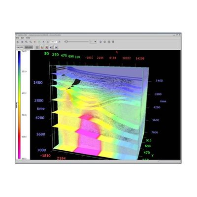
Using GeoThrust, you can process 2D and 3D seismic data and produce the final deliverables including RMS velocity model, depth velocity model, prestack-time migration, prestack-depth migration, post-stack migration, and demigration results.
AS A SEISMIC DATA PROCESSING SERVICE
GeoTomo has a core group of researchers and processors dedicated to providing specialized 2D and 3D data processing services.
GeoTomo offers specialized processing services for areas where the near-surface and structural complexities make it difficult to image the subsurface.
GeoTomo has developed advanced algorithms and workflows for imaging complex geological systems around the world (in both time and depth domains). These workflows include a number of leading edge tomographic techniques designed for optimum statics solutions and to deliver high resolution near-surface velocity models as well as advanced noise attenuation and other signal processing techniques.
- 2D / 3D - time / depth prestack migration from topography
- Migration velocity, gradient, and anisotropic parameters scan along horizons
- Tomography / i-stats image-based near-surface statics
- Reflection / refraction surface-consistent residual statics
- True-amplitude processing
- High-amplitude, random, and coherent noise attenuation in time and space
- Target-oriented multiple attenuation
- Crooked line processing
- Multi-2D lines imaging in 3D to eliminate misties
- 2D / 3D i- cube workflow for subsurface imaging of complex structures
GeoTomo uses state-of-the-art technology that is developed and tested specifically for complex geological systems. GeoTomo uses its vast experience in developing and testing GeoThrust to provide you the best subsurface image possible.