


Utility Location & Mapping
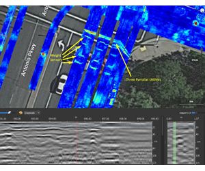
Find More Pipes Than Ever Before: Full digital mapping of subsurface utilities presented in BIM, CAD, and GIS formats. We accomplish this by utilizing the full suite of technical equipment including EM locators, magnetic locators, ground penetrating radar, MCGPR, GNSS, and other geophysical technologies. Bigman Geophysical team consists of the most highly trained and specialized operatives in the industry to generate the highest possible level of quality, often at large and complex projects such as industrial facilities, power plants, and airports.
Reduce Project Downtime
with oversight, remote technical support, and quick deployment of additional equipment
Complete Projects in Record Time
by expanding your team with short term supervisor and/or field technicians deployment
Increase Profits and Customer Retention
by easily adding services through collaboration with our team of experts
Increase Team Effectiveness
through supervision, project debriefing, and on-site training on complex, difficult sites
- Paint marks on the ground surface
- Full summary reports
- 2D and 3D digital maps
- AutoCAD and BIM exports
- GIS compatible exports
- Shareable, Interactive 3D models