
Ai Images
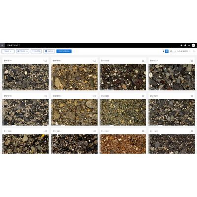
Computer vision and labelling tool for interpreting image data. EarthNET AI Images enables you to interpret image data faster, cheaper and in a more data-driven manner with uncertainty quantified at each step. With generic applicability across images of different types, it includes functionality for image classification, object detection, unsupervised image segmentation, semantic embedding, semi-supervised segmentation and supervised segmentation.
Use the object detection functionality in EarthNET AI Images to identify the class and location of objects within images. This method is well-known from applications such as facial recognition and identifying objects in street images.
In geoscience, this computer vision method can be used to classify, locate, and count different types of rock. You can simply outline classified objects with rectangular bounding boxes. This can also be expanded to instance segmentation, where objects are precisely outlined with segmentation masks.
Use the image classification functionality in EarthNET AI Images to assign a class to each image. During image classification of rock samples, the labelling and deep-learning prediction steps can be supported by the combination of image data with a rich suite of metadata including, stratigraphic information, elemental composition (XRF), mineralogical composition (XRD) and more.
Use the image classification functionality in EarthNET AI Images to to extract very detailed information from images. Our detailed workflow for image segmentation includes rapid annotation, unsupervised segmentation, semantic embedding, and training of supervised segmentation models.
Compute percentages of minerals and lithologies from the segmentation mask and transfer the data to the well-log domain, enabling integration of image data with the well-log and seismic data.
Labeling data can be a time-consuming and expensive task in geoscience work. EarthNET AI Images provides model-assisted labeling functionality that speeds up the labeling process by using pre-trained machine learning models. Our models perform the initial labeling, and human experts review the results and make adjustments if needed.
Another means to speed up data annotation in EarthNET is through programmatic labeling, where you assign appropriate classes using rules based on existing labels, model predictions, and metadata.