

ArcGIS
ArcGIS is a family of software products that form a complete GIS built on industry standards that provide exceptional, yet easy to use, capabilities right out of the box. ArcGIS is a complete, single, integrated system for geographic data creation, management, integration, and analysis. Much more than a specialized offering for a small niche of specialists, ArcGIS is designed as a scalable system that can be deployed in every organization, from an individual desktop to a globally distributed network of people.
ArcGISprovides flexibility when configuring a system since it is modular and scalable. It is modular in the sense that you acquire the system in pieces.
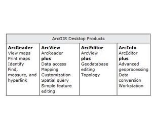
ArcReaderis a free, easy-to-use product that allows anyone to view, explore, and print published map files.
ArcViewincludes all the functionality of ArcReader and provides data visualization, query, analysis, and integration capabilities along with the ability to create and edit simple geographic features.
ArcEditorincludes all the functionality of ArcView and adds the power to create and edit features in a multiuser geodatabase.
ArcInfoincludes all the functionality of ArcEditor and adds advanced geoprocessing capabilities.
ArcSDEis an application server that facilitates storing and managing spatial data (raster, vector, and survey) in a DBMS and makes the data available to many kinds of applications.
ArcIMSprovides the foundation for distributing high-end geographic information systems (GIS) and mapping services via the Internet.
ArcPadsoftware is mobile mapping and geographic information system (GIS) technology.
ArcGIS is scalable since it can be deployed on an individual desktop or across a globally distributed network of people.