
- Home
- Companies
- Changguang Satellite Technology Co., ...
- Software
- Satellite Data Management Software
Satellite Data Management Software
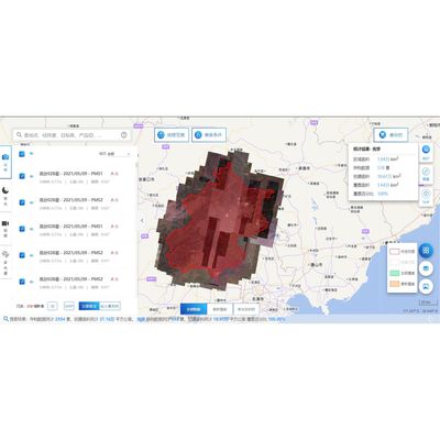
The Satellite Data Management System offered by Chang Guang Satellite Technology Co., Ltd. is designed to be the pivotal hub for storage, management, and application of satellite data products, particularly focusing on the JL1 satellite service. Its robust architecture ensures improved data accuracy through real-time processing and analysis, significantly reducing manual processing errors. This system supports enhanced decision-making by delivering near-real-time information on environmental monitoring aspects like weather, vegetation, and natural disasters, aiding in efficient resource management and timely response to environmental challenges. Additionally, it offers a cost-effective alternative to conventional data collection methods due to its ability to simultaneous cover expansive areas swiftly. Ensuring consistency in data availability over time, it facilitates better monitoring of environmental changes.
- The data management system is the center of the storage, management and application service of satellite data products.
- It is mainly responsible for the storage, organization, application, management and maintenance of JL1 satellite service products.
-
Improved Data Accuracy: With the help of satellite data management systems, satellite data can be processed and analyzed in real-time. This can help improve the accuracy of data as it is less prone to errors caused by manual processing.
-
Better Decision Making: Satellite data management systems can provide near-real-time information about various aspects of the Earth's satellite environmental monitoring, such as weather patterns, vegetation, and natural disasters. This information can help decision-makers make informed decisions regarding resource management, disaster response, and environmental protection.
-
Cost-Effective: Satellite data management systems can be cost-effective compared to traditional data collection methods. For example, satellite data can cover large areas quickly and efficiently, reducing the need for ground-based data collection.
-
Timeliness: Satellite data management systems can provide data in near-real-time, allowing for faster decision-making and response to events such as natural disasters.
-
Consistency: Satellite data management systems can provide consistent data over time, allowing for better tracking of changes in the Earth's environment.
-
Accessibility: Satellite data can be accessed from anywhere in the world, making it a valuable tool for global monitoring and decision-making.
-
Satellite remote sensing technology: Satellite data management systems can be used to monitor remote or hard-to-reach areas that are difficult to access using traditional data collection methods.