
Refine by
Forest Planning Articles & Analysis
25 articles found
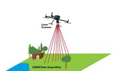
Therefore, Inertial Labs has created a product that will solve many problems related to forest monitoring. Some of these solutions include: By flying over a forest while using LiDAR, users can get a map of elevations and terrain to properly plan road construction, manage tree cutting/planting, and analyze fire risks [10]. ...

In response, the US government developed the National Fire Plan to provide assistance to the areas threatened by wildfires. The National Fire Plan, among its many goals, sought to reduce dry brush and trees that could perpetuate larger wildfires. With funds provided as part of this plan, the USDA Forest Service piloted the Fuels ...

The analysis, Saving Forests at Risk (Chapter 5 in WWF’s ongoing Living Forests Report), delineates 11 sites on four continents totaling some 420 million acres (170 million hectares) that together comprise more than 80 percent of the forest area most at risk of destruction or severe degradation in the next 15 years. ...
ByEnsia
The U.S. Forest Service announced in March that it plans to study the land for potential leasing for oil and gas operations — a plan that was immediately met with fierce opposition from a wide array of outfitters, sportsmen and conservationists, who have been fighting development in the area for more than a decade. ...
ByEnsia

The 204-hectare conservation area near Sebes consists largely of wetlands and floodplain forest. In recent years, the area has seen a strikingly high death rate amongst certain floodplain forest plants. ...
Terrestrial Laser Scanning (TLS) opens new perspectives into the forest ecosystem, no matter if you want to use it to precisely locate and measure natural objects or to present the Genius Loci of a "Plenterwald" with audio-visual effects as shown in the attached video clip, whic is processed from TLS data of some 150 - 200 year old trees growing in a privately owned "Plenterwald" forest in the ...

This year, we made progress on tackling key sustainability challenges, including addressing climate change, promoting clean energy, ensuring food security and stable water supplies, reducing forest degradation, and creating sustainable cities. Take a look at our nine top outcomes: 1) “Four-Point Plan” Informs President Obama’s U.S. Climate ...
For example, how do you measure deforestation and forest degradation, how do you ensure the rights of forest-dependent communities, and who exactly should provide the funding? ...
Some of the issues include: Abuse of the Forest Source Document system (DOF): The DOF tracks and cross checks timber harvested from a forest operation against the volume of timber approved by the government under the forest management plan. ...
The government of Nova Scotia announced an ambitious plan earlier this month to protect 245,000 hectares of forest and park land, establishing the Canadian province as a conservation leader in one of the world’s most heavily forested nations. ...
It’s a critical first step for improving land-use planning and forest management. However, due to conflicts between national and subnational governments, Indonesia’s forest delineation process is only 14 percent complete. ...

This study uses Landsat 7 ETM and IKONOS satellite data to estimate the priority areas for reforestation in a forest management planning unit of Turkey. Three important parameters, crown closure, slope and soil moisture, were used to identify potential reforestation areas. The existing crown closure classes were obtained from the forest stand ...
Im Oktober 2011 wurde die Bürogemeinschaft landConsult.de in Bühl/Baden und ProGea Consulting in Krakau vom Staatsbetrieb Sachsenforst beauftragt, Luftbild- und Laserdaten ertragsförderlicher Versuchsflächen im Erzgebirge auszuwerten. Ziel ist die vollständige Vermessung der Einzelbaumkronen anhand der Fernerkundungsdaten sowie der Vergleich mit den vom Boden aus ...

John Parrotta, an international forest-science policy analyst with the US Forest Service and chair of the committee that prepared the report, says that deforestation and forest degradation must be checked to boost biodiversity and help remove carbon from the atmosphere. ...
The Interactive Forest Atlas of Cameroon is a living forest information system hosted in the Ministry of Forestry and Wildlife (MINFOF) and supported by a joint team including members from MINFOF and the World Resources Institute (WRI). Built on a geographic information system (GIS) platform, the atlas provides unbiased and up-to-date information on the ...

The alternative is to selectively cut only mature trees, leaving the forest largely intact. This ensures that forest productivity can be maintained in perpetuity. Forest plantations can reduce pressures on the earth’s remaining forests as long as they do not replace old-growth forest. ...
Forests are essential to our survival and well-being. Forests clean our air, our water, our soil and they regulate our climate, amongst many other things. ...
The role of England?s Community Forest programme has constantly diversified since its creation in 1990. ...

The main objective of this work was to develop a multiple use forest management planning model, focusing on the economic effects of some forest management policy constraints on timber and water production values for forest ecosystems. ...
Currently, because of water scarcity created by global climate change, integrating of water values provided from forest ecosystem into forest management planning has become great important. This research integrated water values into forest management planning and explained their effects on forest ...