

DroneDeploy
- Home
- Companies
- DroneDeploy
- Software
- Complete Drone Data Analysis Software
Complete Drone Data Analysis Software
FromDroneDeploy
Unify Your Data: Compare different data sets to gather rich insights over time. Collaborate from Anywhere: Connect your team with an interactive, up-to-date visual record of your project. Measure and Report: Measure volume, slope and distance, and generate professional reports at the click of a button. Automate Insights: Insights you need with automatic detection & counting of objects like stockpiles, trees, and cars.
Most popular related searches
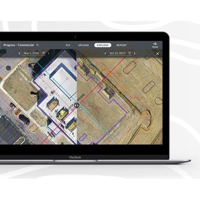
Explore Data in One Place
Analyze reality to make more informed decisions
- View and compare elevation, plant health, and thermal data
- Compare as-built to as-designed with design plan overlays
- Explore 2D maps, 3D models, photos, panoramas, and videos in a single solution
Collaborate from Anywhere
The flexibility and agility to share on site or back in the office
- Explore maps, photos, videos, and panoramas on any device
- Add comments, annotations, and measurements to any map in 2D or 3D
- Receive updates and access the latest data
Accurate Measurements and Reports
Quickly assess progress, issues, and opportunities
- Accurately measure volume, slope, and distance
- Evaluate progress and validate work with Earthworks analysis
- Report value and quantify inventory with Stockpile Reporting
Save Time and improve accuracy
- Automate counting and other manual tasks, such as, counting trees or cars
- Detect stockpiles for inventory management automatically
- Systematically identify and geolocate the most popular types of GCP markers