

DroneDeploy
- Home
- Companies
- DroneDeploy
- Software
- Data Capture Software
Data Capture Software
FromDroneDeploy
Easily capture any angle of your site, from the air or the ground, with user friendly flight and walkthrough mobile applications that help you create accurate digital maps and models.
Most popular related searches
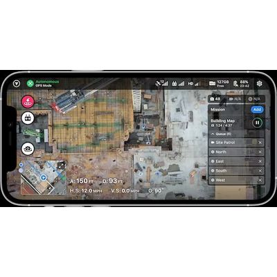
Autonomous Drone Missions
Easily create maps, 3D models, panoramas, and videos
Ground-Level Walkthroughs
Walk your job-site and capture continuous 360 footage
Real-Time Insights
Generate maps in real-time, entirely offline, with Live Map
Autonomous drone flights and ground-based walkthroughs allow you to virtually document every stage of your construction project, capture every angle of your asset, or visualize your entire field.
- Perfect your reality capture drone experience with autonomous or manual missions, customized pre-flight checklists, and mission-chaining
- Quickly capture data for mapping, modeling, marketing, reporting, or inspections, all from a single flight application
- Request LAANC airspace authorization on-site or in advance
- Upload reality capture data directly to your project while on site
- Utilize the DroneDeploy Walkthrough App to collect and upload reality capture data for ground-based 360 Walkthroughs
- Capture with the settings that are tuned for best processing in DroneDeploy and reduce file size by up to 10x
- Align your media to design files or project floor plans
- Upload your media to the appropriate project in DroneDeploy directly from your iOS device while in the field