
Refine by
Meteorology Modeling Articles & Analysis
204 articles found
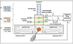
Remote monitoring of ship emissions using an aerosol single-particle mass spectrometer and localization via backward trajectories – Ship Emission Profiler (SEP-3AP) 1. Initial situation (2021) The global maritime transport of goods is an important part of globalization and contributes to prosperity in society. However, the ecological footprint of this transport system and the cruise ...
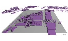
For dispersion calculations in accordance with the Technical Instructions on Air Quality Control (TA-Luft), meteorological data is generally used that is either measured at the site or, if no on-site measurements are available, transferred there (QPR) or based on model calculations.Meteorological data has to be transferred in accordance with guideline VDI 3783 ...

When it comes to agriculture, weather is an important aspect that determines crop health and yield. Unpredictable weather patterns pose a continuous challenge to farms, often leading to substantial crop losses and financial setbacks. However, with the innovation of advanced technology, leveraging weather data in agriculture has become a critical tool in crop management. By integrating weather ...
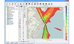
Lakes Software recently announced its acquisition of the CALPUFF modeling system from Exponent. Because Lakes’ CALPUFF View interface is well known throughout the modeling community, some modelers were not aware of the differences between this application and the stand-alone modeling system. This tip will explain the relationship between the modeling system and the CALPUFF View ...

Directly comparing wind roses from two different sets of meteorological data is a great way to compare how similar the data is. This is commonly done when comparing observational data to that generated with a meteorological model such as WRF or MM5. ...
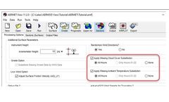
When conducting an air dispersion modeling analysis, it is very important that the meteorological data quality is as high as possible. AERMET – the meteorological pre-processor for the AERMOD dispersion modeling system – contains internal options which can boost data quality by filling short gaps of missing cloud ...
When conducting an air dispersion modeling analysis with the AERMOD modeling system, modelers may encounter situations where they want to validate or verify the model’s calculations. ...

We’ll dive into this in four parts: a brief review of methods, historical time-series data, typical meteorological year data and monthly averages. How Solcast creates solar GIS data Solcast operates our own unique algorithms and proprietary modelling framework for estimating solar irradiance via geostationary weather satellite data. ...
BySolcast

Tmonitor these compounds online CHROMATOTEC® offers high meteorological solutions. Odors are very distinct air contaminants as they generate nuisances. ...
To monitor these compounds online CHROMATOTEC® offers high meteorological solutions. As a result of the confinement of the waste water stations, toxic components such as H2S and Methylmercaptan increased. ...

A one-dimensional vadose zone model was used to simulate flow under natural boundary conditions. The effects of hysteresis and temporal variability of meteorological conditions were evaluated. ...

This research has expanded to develop a relationship between soil moisture levels and the impact on meteorological and hydrological models and forecasts. Starting in the late 1970s, the meteorological community became interested in soil moisture after studies were published addressing thermal fluxes between the atmosphere and the ...

NAAQS-specific processing when necessary. Non-U.S. modelers and those modeling for a purpose other than comparison to the U.S. ...
For this purpose, a specific module dedicated to simulating the hydrological behaviour of a green roof has been developed in the distributed rainfall–runoff model (Multi-Hydro). It has been applied on a French urban catchment where most of the building roofs are flat and assumed to accept the implementation of a green roof. Catchment responses to several rainfall events covering ...
In phase 1 and 2, an overlay method was developed that combined data from radar, optical remote sensing and ground measurement (geology, hydrogeology, hydrology, hydro-meteorology, and geophysics). The overlay model identified the most promising site to undertake well drilling, considering a probability of drilling wells with sufficient amount of water and ...
Rainfall forecasts issued through the Australian Bureau of Meteorology are based on general circulation models (GCMs) and have a poor skill levels. ...
The partial thin plate smoothing splines method was applied to evaluate spatiotemporal trends of precipitation in the Yellow River basin from 1981 to 2013 by considering the basin's digital elevation model. Results indicate the following. (1) The spline method can greatly improve the spatial interpolation accuracy of meteorological data and can be applied to ...
Previous studies evaluating droughts were from meteorological and hydrological perspectives. We measure the Chinese drought of 2000 based on a static computable general equilibrium model of China's macroeconomy, which describes the relationships between drought, agricultural production, and rural households' welfare from an economic perspective. In the ...
While most air dispersion modeling is conducted using meteorological data from recent past years and historical or projected emissions data, models can also be used with real-time or short-term forecast meteorological and emissions data to estimate impacts at the present time and in the near future. In order to develop these ...

The numerical simulation with different species of ice nuclei is investigated using an explicit bulk-water microphysical scheme in a Mesoscale Meteorological Model version 5 (MM5). The species dependent ice nucleation parameterization that is based on the classical nucleation theory has been implemented into the model. ...